The Complete Guide to the Annapurna Circuit Trek
Everything you need to know about trekking the Annapurna Circuit. Route, itinerary, cost, Thorong La Pass, Tilicho Lake, best season, difficulty, permits, and how to choose the right package.
The Annapurna Circuit trek is widely regarded as one of the greatest long-distance treks in the world. It circles the entire Annapurna massif in central Nepal, crossing through subtropical lowlands, terraced farmlands, dense forests, alpine meadows, high-altitude desert, and over Thorong La Pass at 5,416 meters, one of the highest trekking passes on the planet.
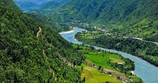
What makes the Annapurna Circuit unique is its diversity. No other single trek in Nepal packs this much variety of landscape, culture, and climate into one continuous route. You start in warm, green river valleys where rice paddies line the trail. Within days, the scenery transforms into arid, wind-swept terrain that resembles Tibet more than Nepal. And the culture shifts with it, from Hindu villages on the eastern side to Tibetan Buddhist communities in the west.
Whether you are planning your first Himalayan trek or looking for the definitive circuit experience, this guide covers everything you need.
What Is the Annapurna Circuit?
The Annapurna Circuit is a long-distance trekking route that loops around the Annapurna massif in central Nepal. The total length ranges from 160 to 230 kilometers depending on your starting point, ending point, and which side trails you include.
The classic route begins at Besisahar (or nearby Bhulbhule) in the Marsyangdi River valley on the eastern side. It follows the Marsyangdi upstream, gradually gaining altitude through villages like Dharapani, Chame, Pisang, and Manang. After an acclimatization stop in Manang, the trail climbs steeply to Thorong La Pass at 5,416 meters before descending to Muktinath on the western side. From there, the route continues down through the Kali Gandaki gorge, one of the deepest gorges in the world, passing through Kagbeni, Jomsom, and Marpha.
The trek sits entirely within the Annapurna Conservation Area (ACA), covering over 7,600 square kilometers of protected land. It is home to diverse ecosystems and ethnic communities including the Gurung, Manangi, and Thakali people.
The Annapurna region was opened to foreign trekkers in 1977, and the circuit quickly became one of the most sought-after trekking routes globally. It has been voted the best long-distance trek in the world multiple times for its combination of scenery, culture, and challenge.
Why Trek the Annapurna Circuit?
Unmatched Landscape Diversity
The Annapurna Circuit trail passes through five distinct ecological zones in a single journey: subtropical (below 1,000m), temperate (1,000m to 2,000m), subalpine (2,000m to 3,000m), alpine (3,000m to 4,500m), and trans-Himalayan high desert (above 4,000m on the rain shadow side). You walk through rice paddies, bamboo forests, pine groves, barren high-altitude desert, and snow-covered mountain passes all on the same trek.
Thorong La Pass
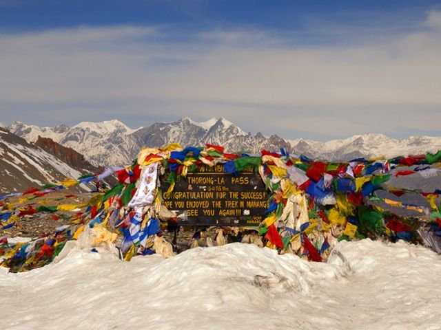
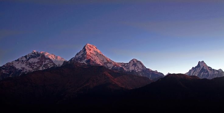
Crossing Thorong La at 5,416 meters is the defining moment of the Annapurna Circuit trek. It is one of the highest trekking passes in the world. The early morning climb, the sense of achievement at the top, and the panoramic views of the Annapurna and Dhaulagiri ranges make it unforgettable. The highest point of the Annapurna Circuit is what draws many trekkers to this route.
Cultural Depth
The trail passes through Hindu, Buddhist, and mixed communities. Gurung and Manangi villages on the east give way to Tibetan Buddhist culture after Thorong La. Muktinath Temple at 3,710 meters is sacred to both Hindus and Buddhists, featuring 108 water spouts and an eternal flame. The Thakali villages of Marpha and Tukuche are known for their distinctive cuisine, apple orchards, and warm hospitality.
World-Class Mountain Views
The Annapurna Circuit provides close-up views of over a dozen major peaks: Annapurna I (8,091m), Annapurna II, III, and IV, Dhaulagiri (8,167m), Machhapuchhre (6,993m), Gangapurna (7,455m), Tilicho Peak (7,134m), Manaslu (8,163m in the distance), Nilgiri, Lamjung Himal, Pisang Peak, and Chulu peaks. The variety of angles as you circle the massif means you never see the same view twice.
The Kali Gandaki Gorge
The descent from Muktinath follows the Kali Gandaki River through one of the deepest gorges in the world, flanked by Dhaulagiri (8,167m) on one side and Annapurna I (8,091m) on the other. Walking through this corridor is one of the most dramatic experiences on any trek anywhere.
Annapurna Circuit Trek Route Options
The Classic Annapurna Circuit Trek
The full classic Annapurna Circuit trek follows the traditional route from Besisahar through Manang, over Thorong La, down to Muktinath, and through the Kali Gandaki to Jomsom or further to Tatopani and Ghorepani (Poon Hill). This takes 18 to 21 days and covers the maximum diversity of landscape and culture. Road construction has affected some lower sections, so many trekkers now start from Chame or Dharapani to skip the road-heavy portions.
Short Annapurna Circuit Trek
For trekkers with limited time, a short Annapurna Circuit trek is possible in 10 to 14 days. These shorter versions typically start from Chame or Upper Pisang (reached by jeep from Besisahar), cutting out the lower-altitude road sections. You still cross Thorong La and experience the core highlights of the circuit, but with less time in the eastern valley.
A 12-day Annapurna Circuit trek is one of the most popular shortened versions, starting from Chame and ending in Jomsom with a flight or drive back to Pokhara.
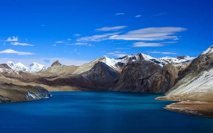
Annapurna Circuit with Tilicho Lake
One of the most rewarding extensions is adding Tilicho Lake to the circuit. Tilicho Lake sits at 4,919 meters and is one of the highest lakes in the world. The side trip from Manang to Tilicho Lake and back takes 2 to 3 extra days. The trail passes through Tilicho Base Camp and climbs to the lake through rocky, exposed terrain with stunning views. This adds significant value to the trek and is increasingly popular among trekkers who want the complete Annapurna experience.
Annapurna Circuit with Poon Hill
Some trekkers extend the circuit beyond Jomsom, continuing south through Tatopani (natural hot springs) to Ghorepani and Poon Hill. The famous Poon Hill sunrise, a panoramic view of Dhaulagiri, Annapurna South, and Machhapuchhre, is a fitting finale to the circuit. This extension adds 3 to 4 days.
Annapurna Circuit from Pokhara
While the traditional starting point is Besisahar (reached by road from either Kathmandu or Pokhara), many trekkers begin their journey from Pokhara since it serves as the gateway city to the Annapurna region. From Pokhara, you can drive to Besisahar (4 to 5 hours) or take a jeep directly to Chame or Dharapani to start the trek at a higher point. The circuit typically ends in Jomsom, from where you fly or drive back to Pokhara.
Manaslu Annapurna Circuit Combination
For experienced trekkers wanting a longer expedition, the Manaslu Circuit can be combined with the Annapurna Circuit for a 25 to 30-day trek that covers two of Nepal's greatest routes. This requires a special restricted area permit for Manaslu and is best done with a registered trekking company.
Annapurna Circuit Trek Itinerary
The standard itinerary runs 15 to 17 days. Here is a typical day-by-day breakdown for the most popular version.
Day 1: Arrive in Kathmandu. Airport transfer and evening briefing.
Day 2: Drive to Chame (2,670m). Long drive day (8 to 10 hours) from Kathmandu via Besisahar, following the Marsyangdi River. The road is rough beyond Besisahar. First views of Lamjung Himal and Annapurna II.
Day 3: Trek from Chame to Upper Pisang (3,300m). Walk through pine forests, apple orchards at Bhratang, and narrow river gorges with dramatic rock walls. First panoramic views of the Annapurna range open up near Pisang. Trek: 15 km, 5 to 6 hours.
Day 4: Trek from Upper Pisang to Manang (3,540m). Take the upper route through Ghyaru and Ngawal for the best views of Annapurna II, III, IV, Gangapurna, and Tilicho Peak. Trek: 17 km, 6 to 7 hours.
Day 5: Acclimatization day in Manang. Essential rest day. Options include a hike to Gangapurna Lake, Praken Gompa (monastery with panoramic views), or Ice Lake (4,600m). Do not skip this day.
Day 6: Trek from Manang to Yak Kharka (4,050m). Gradual climb through sparse vegetation and yak pastures. The landscape becomes increasingly barren and alpine. Trek: 9 km, 4 to 5 hours.
Day 7: Trek from Yak Kharka to Thorong Phedi (4,540m). Short but steep climb to the base camp for the Thorong La crossing. Afternoon rest is critical for the early morning pass attempt. Trek: 6 km, 3 to 4 hours.
Day 8: Cross Thorong La Pass (5,416m) to Muktinath (3,760m). The big day. Start at 4 AM. Steep climb for 3 to 4 hours to the pass. Panoramic views at the top. Long descent (1,600m drop) to Muktinath. Visit the sacred Muktinath Temple. Trek: 15 km, 8 to 10 hours.
Day 9: Trek from Muktinath to Kagbeni (2,800m). Descent through the rain shadow landscape into the upper Kali Gandaki valley. Kagbeni is a medieval-looking village at the gateway to Upper Mustang. Trek: 11 km, 3 to 4 hours.
Day 10: Trek from Kagbeni to Jomsom (2,720m). Walk along the Kali Gandaki River through dramatic gorge scenery. Jomsom is a larger town with an airstrip. Trek: 10 km, 3 to 4 hours.
Day 11: Trek from Jomsom to Marpha to Kalopani (2,530m). Pass through Marpha, famous for apple orchards, apple brandy, and Thakali cuisine. Continue to Kalopani with views of Dhaulagiri. Trek: 15 km, 5 to 6 hours.
Day 12: Trek from Kalopani to Tatopani (1,190m). Long descent through the Kali Gandaki gorge. Tatopani means "hot water," and the natural hot springs here are a perfect reward for tired muscles. Trek: 18 km, 6 to 7 hours.
Day 13: Trek from Tatopani to Ghorepani (2,860m). A tough climb but worth it. Ghorepani is the staging point for the famous Poon Hill sunrise. Trek: 12 km, 6 to 7 hours.
Day 14: Poon Hill sunrise, trek to Nayapul, drive to Pokhara. Early morning hike to Poon Hill (3,210m) for panoramic sunrise views. Descend through Ulleri and Birethanti to Nayapul. Drive to Pokhara (1.5 hours). Trek: 14 km, 5 to 6 hours.
Day 15: Pokhara. Rest day. Lakeside exploration, optional paragliding, or fly to Kathmandu.
Day 16: Departure. Transfer to airport.
This itinerary can be shortened by ending at Jomsom (fly to Pokhara) instead of continuing to Poon Hill, or lengthened by adding Tilicho Lake, Ice Lake, or Upper Mustang extensions.
Best Season for the Annapurna Circuit Trek
Autumn (October to November)
The best season. Clear skies, stable weather, excellent visibility, and comfortable temperatures. October is peak season with the highest number of trekkers on the trail. November is slightly quieter with cooler temperatures but equally good views. This is when Thorong La is most reliably open.
Spring (March to May)
The second-best window. Warmer temperatures, rhododendron forests in bloom (March to April), and good visibility in the mornings. Afternoon clouds are more common than in autumn. Late May can bring early monsoon showers at lower altitudes. Thorong La is usually clear by late March.
Winter (December to February)
Challenging but possible. Lower sections are manageable, but Thorong La can be blocked by heavy snow. Temperatures drop sharply above 3,000 meters. Fewer tea houses remain open. The Annapurna Circuit in December is doable with the right gear and experience, but January and February carry higher risk of pass closure.
Monsoon (June to September)
Generally not recommended for the full circuit. However, the northern sections (Manang to Jomsom) sit in a rain shadow and receive significantly less rainfall than the southern slopes. Some trekkers do partial circuits during monsoon, but trail conditions, leeches, and limited visibility make it less enjoyable. The Annapurna Circuit in September is possible as monsoon weakens, but conditions are variable.
Annapurna Circuit Trek Cost
Group Packages
Standard group Annapurna Circuit trek packages typically cost between $1,000 and $1,800 USD per person. This generally includes permits (ACAP and TIMS), a licensed guide, tea house accommodation, meals on the trail (breakfast, lunch, dinner), and ground transportation to and from the trailhead.
Private Packages
Private trek packages range from $1,800 to $3,500 USD per person. These include a dedicated guide, porter, flexible pacing, and often better tea house rooms booked in advance.
Luxury Annapurna Circuit Trek
Premium and luxury packages range from $3,500 to $6,000+ USD per person. These include upgraded lodges where available, private rooms throughout, helicopter transfers for certain sections, better food options, and full concierge-level service.
What Affects the Price
Duration (longer treks cost more), group size (larger groups lower per-person costs), season (peak season may carry premiums), side trips (Tilicho Lake, Poon Hill, or Upper Mustang extensions add days and cost), and accommodation tier.
What's Typically Not Included
Travel insurance, international flights, Nepal visa fees, personal gear, tips for guides and porters, hot showers and Wi-Fi on the trail, snacks, drinks, and personal expenses.
Trekking Cost Per Day
On a standard group package, the all-inclusive trekking cost works out to approximately $80 to $120 USD per day. Private packages run $120 to $200 per day. Budget-conscious independent trekkers spending on tea houses, food, and permits directly can expect $30 to $50 per day, excluding guide and porter fees.
Permits Required
ACAP (Annapurna Conservation Area Permit)
Approximately $30 USD for foreign nationals, $5 USD for SAARC nationals. Supports conservation of the Annapurna Conservation Area.
TIMS (Trekkers' Information Management System) Card
Approximately $20 USD for group trekkers, $40 USD for independent (FIT) trekkers. Used for trekker safety tracking.
Both permits can be arranged in Kathmandu or Pokhara. If you book with a trekking company, permits are handled as part of the package.
Additional permits are required if you extend to Upper Mustang or Nar Phu Valley (restricted area permits, significantly more expensive).
Difficulty and Fitness Requirements
The Annapurna Circuit trek is rated moderate to challenging. The main difficulty factors are the long duration (12 to 20 days of continuous trekking), crossing Thorong La Pass at 5,416 meters, daily walking of 5 to 7 hours on varied terrain, and significant cumulative elevation gain and loss.
Who Can Do This Trek?
The circuit is suitable for fit adults aged 18 to 65 with good cardiovascular fitness. You should be comfortable walking 5 to 7 hours per day on uneven terrain for consecutive days. Regular cardio training (running, cycling, hiking) for 6 to 8 weeks before departure is strongly recommended.
Previous trekking experience is helpful but not strictly required if you prepare properly. However, the Annapurna Circuit is more demanding than the Annapurna Base Camp trek due to the higher altitude, longer duration, and the Thorong La crossing.
Altitude Sickness
The maximum altitude is 5,416 meters at Thorong La, which is high enough for serious altitude sickness. The standard itinerary includes acclimatization days in Manang and gradual altitude gain, but every person responds differently.
Key prevention: ascend gradually, drink 3 to 4 liters of water daily, avoid alcohol above 3,000 meters, eat carbohydrate-rich meals, and never push through worsening symptoms. Descend immediately if symptoms escalate. Many trekkers carry Diamox (Acetazolamide) as a preventive aid. Consult your doctor before taking it.
Thorong La Pass Day
The pass day is the most physically demanding day of the trek. You start at 4 AM from Thorong Phedi (4,540m), climb 876 meters to the pass in 3 to 4 hours, then descend 1,600 meters to Muktinath. The total walking time is 8 to 10 hours. Good fitness, proper acclimatization, and an early start are essential. Your guide will assess weather and group condition before attempting the crossing.
Training and Preparation
6 to 8 Weeks Before
Start regular cardiovascular exercise: running, cycling, swimming, or brisk walking for 30 to 45 minutes, four to five times per week. Add stair climbing with a loaded backpack (8 to 10 kg) to simulate trail conditions.
4 to 6 Weeks Before
Increase cardio sessions to 60 to 90 minutes. Do weekend hikes on hilly terrain. Walk on uneven ground to strengthen ankles. Break in your trekking boots.
2 to 4 Weeks Before
Do two long walks (4 to 6 hours) on consecutive days to simulate back-to-back trekking. Include elevation gain. Stretch regularly, focusing on calves, quads, hamstrings, and hip flexors.
The Week Before
Taper training. Light walks and stretching. Focus on rest, hydration, and nutrition.
What to Pack
The Annapurna Circuit uses tea house accommodation throughout, so no camping gear is needed. If you hire a porter, your main bag is carried for you.
Clothing
Moisture-wicking base layer, insulating mid-layer (fleece or down jacket), waterproof and windproof outer shell, trekking pants, thermal underwear for cold nights and the pass day, warm beanie, sun hat, gloves (lightweight and insulated pair), neck gaiter or buff, and enough socks for the duration (merino wool recommended).
Footwear
Waterproof trekking boots with ankle support (broken in), lightweight sandals for tea house evenings, and gaiters for snowy or muddy sections near Thorong La.
Gear
Sleeping bag rated to at least -15°C (the pass and high camps are colder than ABC), 30 to 40-liter daypack, trekking poles (essential for the long descent from Thorong La), headlamp with spare batteries, refillable water bottle, water purification tablets or UV purifier, and dry bags for electronics.
Documents and Money
Passport, permit copies, travel insurance documents with helicopter evacuation coverage, Nepali rupees in small denominations (no ATMs on the trail beyond Jomsom), and a power bank.
Tea Houses and Accommodation
The entire Annapurna Circuit route has tea house accommodation. Quality varies significantly across the trek.
Eastern Section (Besisahar to Manang)
Simple but functional lodges. Basic rooms with twin beds, shared bathrooms. Hot showers available at most stops. Menus are varied with both Nepali and Western options.
Manang
Better accommodation options. Some lodges offer private rooms with better bedding. Good place to rest and prepare for Thorong La.
Thorong Phedi and High Camp
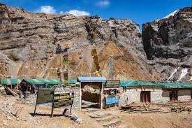
Basic facilities. Dormitory-style rooms. Limited menu. No reliable hot water. This is the most basic accommodation on the circuit, but you only spend one night here.
Western Section (Muktinath to Jomsom to Tatopani)
Comfortable lodges, especially in Jomsom and Marpha. Some lodges in this section offer private rooms with attached bathrooms. The Thakali region is known for better food and hospitality.
Food
Dal bhat is the staple everywhere. The Thakali section (Marpha, Tukuche) is known across Nepal for exceptional dal bhat with diverse side dishes. Apple pie, apple cider, and apple brandy from Marpha's orchards are local specialties. At higher altitudes, menus become simpler and prices increase.
Trekking Solo on the Annapurna Circuit
Solo trekking on the Annapurna Circuit is permitted and many trekkers do it independently. The trail is well-marked, tea houses are plentiful, and you'll meet other trekkers along the way.
However, we recommend trekking with a local guide, especially for the Thorong La crossing. A guide manages logistics, monitors weather, handles permit checks, reserves tea house rooms (important in peak season), and watches for altitude sickness symptoms. For solo trekkers, a guide also provides security and companionship on longer, more remote sections.
If you do trek solo, register with your embassy, carry a fully charged phone, share your itinerary with someone at home, and don't attempt Thorong La in bad weather.
Safety Considerations
Weather
Weather changes rapidly at altitude. Clear mornings can turn into afternoon storms. Always carry rain gear and warm layers. Your guide will monitor conditions, especially before the Thorong La crossing.
Thorong La Risks
The pass can be blocked by snow in winter and early spring. Blizzards, though rare, can be dangerous. In October 2014, a sudden blizzard on the circuit killed over 43 people. Always follow your guide's advice on whether to attempt the crossing. Do not push through in poor visibility or heavy snow.
Trail Conditions
Road construction has affected some lower sections of the circuit. The Natural Annapurna Trekking Trails (NATT) project has created alternative paths that avoid the road. Your guide will know which trails to use.
Emergency Evacuation
Helicopter evacuation is available from most points along the circuit. Travel insurance with emergency helicopter coverage is mandatory. Evacuation costs can exceed $5,000 USD without insurance.
The Annapurna Circuit vs Other Treks
Annapurna Circuit vs Annapurna Base Camp
The circuit is longer (12 to 20 days vs 10 to 14 days), reaches higher altitude (5,416m vs 4,130m), and offers far more landscape and cultural variety. ABC delivers one dramatic destination (the amphitheatre). The circuit delivers an entire journey. Choose ABC if you have limited time. Choose the circuit if you want the full Annapurna experience.
Annapurna Circuit vs Everest Base Camp
Both are iconic Nepal treks. The Annapurna Circuit offers more landscape diversity, cultural variety, and a higher pass crossing. EBC offers closer proximity to Everest and the Khumbu region. The circuit is generally considered more varied. EBC is considered more dramatic in terms of single-peak focus.
Environmental Responsibility
The Annapurna Conservation Area faces growing pressure from tourism. As a trekker, carry out all your trash, use refillable water bottles with purification, stay on marked trails, respect wildlife, support tea houses that practice responsible waste management, and minimize water usage at higher altitudes.
What to Expect Day by Day
Beyond the itinerary, here's what the experience actually feels like.
The Eastern Valley (Chame to Manang)
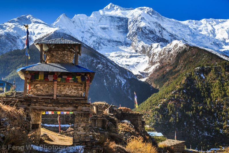
The first few days are about settling into the rhythm. The Marsyangdi River is your constant companion as the trail climbs through narrow gorges and pine forests. The landscape changes noticeably each day. Chame is a small district headquarters with basic services and your first big mountain views. The walk from Chame to Pisang passes through one of the most dramatic gorge sections on the circuit, with massive rock walls towering above the trail.
Upper Pisang is where the Annapurna Circuit starts to show its hand. The views of Annapurna II and Pisang Peak from the village are stunning. Taking the upper trail from Pisang to Manang (through Ghyaru and Ngawal) is highly recommended. This high route offers continuous panoramic views that the lower trail misses entirely.
Manang itself is a fascinating place. The village sits at 3,540 meters in a wide, dry valley. The landscape on one side of the Marsyangdi is forested, while the other side is almost barren. You can feel the shift from the green eastern valley to the arid trans-Himalayan zone. The acclimatization day here is not just important for your body. It gives you time to explore Gangapurna Lake, visit the monastery at Praken Gompa, or attempt the hike to Ice Lake at 4,600 meters.
The Pass (Thorong La)
The night before the pass is tense. Everyone at Thorong Phedi goes to bed early, and the alarm goes off around 3:30 AM. Breakfast in the cold, headlamps on, and you start climbing in the dark.
The first two hours are steep and relentless. You climb switchbacks on a rocky trail, breathing hard in the thin air. Other trekkers' headlamps string out above and below you like a slow-moving procession. As dawn breaks, the mountains reveal themselves, and the trail levels out for the final approach to the pass.
Reaching the top of Thorong La is emotional. Prayer flags everywhere. The wind is fierce. The views stretch across both the Annapurna and Dhaulagiri ranges. Most people spend 10 to 15 minutes at the top before the cold forces them to start the descent.
The descent to Muktinath is long (1,600 meters of elevation loss) and hard on the knees. Trekking poles are essential. By the time you reach Muktinath in the afternoon, you've been walking for 8 to 10 hours and dropped from the Arctic to the desert.
The Western Side (Muktinath to Jomsom)
After the intensity of the pass, the western side feels like a different country. The landscape is dry, open, and wind-swept. The Kali Gandaki valley stretches wide with Dhaulagiri and Nilgiri dominating the skyline. Kagbeni, with its medieval architecture and narrow alleys, feels like stepping back centuries. It sits at the gateway to Upper Mustang, and the Tibetan Buddhist influence is strong.
Jomsom is the largest town on this section, with an airstrip, shops, and better lodges. Many trekkers end their circuit here and fly back to Pokhara (a spectacular 20-minute flight through the Kali Gandaki gorge).
The Thakali Country (Marpha to Tatopani)
If you continue past Jomsom, you enter Thakali country. Marpha is one of the most charming villages on the entire circuit. Clean stone streets, whitewashed houses, apple orchards, and the best food on the trail. Thakali dal bhat with its twelve-side-dish spread is legendary. Apple pie, apple cider, and apple brandy are local specialties you won't find anywhere else.
The descent to Tatopani takes you through the deepest section of the Kali Gandaki gorge. Tatopani's natural hot springs are the perfect recovery stop. Soaking sore muscles in warm mineral water after two weeks of walking is one of the simple pleasures that make the circuit special.
Poon Hill Finale
If you extend to Ghorepani, the final day features the famous Poon Hill sunrise. A pre-dawn climb to 3,210 meters rewards you with a 360-degree panorama of Dhaulagiri, Annapurna South, Machhapuchhre, and the surrounding ranges. It's a fitting end to a trek that began in a river valley and crossed the highest pass in the region.
Guides and Porters
Do You Need a Guide?
Independent trekking is permitted on the Annapurna Circuit. However, a licensed local guide adds significant value: managing logistics, handling permit checks, reserving tea house rooms (critical in peak season), monitoring weather before the Thorong La crossing, watching for altitude sickness symptoms, and sharing knowledge about the culture and history of every village you pass through.
For the Thorong La crossing specifically, an experienced guide who knows the weather patterns and trail conditions can be the difference between a safe crossing and a dangerous situation.
Do You Need a Porter?
A porter carries your main bag (up to 15 to 20 kg), leaving you with just a daypack. On a trek as long as the circuit, this makes a significant difference in daily energy and joint stress. The long descent from Thorong La to Muktinath is particularly brutal on the knees without a porter taking the load.
You can hire a guide-porter (one person doing both roles) for a lower cost if you're traveling solo or as a couple.
Photography Tips
Key Shots on the Circuit
The Pisang Peak reflection from Upper Pisang, the wide valley panorama from Ghyaru, Gangapurna Lake with its turquoise water, the barren landscape approaching Thorong La, prayer flags at the pass, the descent to Muktinath with Dhaulagiri behind you, Kagbeni's medieval streets, the Kali Gandaki gorge with 8,000-meter walls, Marpha's stone alleys, and the Poon Hill sunrise panorama.
Gear Tips
A wide-angle lens (16 to 35mm equivalent) is the most useful for mountain landscapes. Carry spare batteries as cold drains them fast. Keep your camera in an inside jacket pocket near Thorong La. Allow equipment to adjust to temperature changes gradually between cold outdoor air and warm tea houses.
Best Light
Golden hour at Manang and Pisang. Sunrise from Thorong La (if conditions allow a pause). Late afternoon light in the Kali Gandaki with Dhaulagiri. Poon Hill sunrise is the single best light opportunity on the circuit.
Frequently Asked Questions
How long is the Annapurna Circuit trek?
The full circuit covers 160 to 230 kilometers and takes 15 to 21 days. Shortened versions (starting from Chame) take 10 to 14 days.
How much does the Annapurna Circuit trek cost?
Group packages range from $1,000 to $1,800 USD. Private packages from $1,800 to $3,500 USD. Luxury packages from $3,500 to $6,000+ USD. All per person, typically including permits, guide, accommodation, and meals.
What is the highest point on the Annapurna Circuit?
Thorong La Pass at 5,416 meters (17,769 feet). This is the highest trekking pass in the Annapurna region.
Can beginners do the Annapurna Circuit?
It's possible with proper fitness preparation and a good guide, but the circuit is more demanding than shorter treks like Poon Hill or ABC. First-time trekkers should consider the standard (not shortened) itinerary for proper acclimatization.
Can I trek the Annapurna Circuit solo?
Yes, solo trekking is permitted. However, we recommend hiring a local guide, especially for the Thorong La crossing, for safety, logistics, and a richer experience.
What is the best month for the Annapurna Circuit trek?
October and November offer the best conditions. March to May is the second-best window. December is possible but risky due to snow on Thorong La.
Is Tilicho Lake worth adding to the circuit?
Absolutely. Tilicho Lake at 4,919 meters is one of the highest lakes in the world and adds 2 to 3 days to the trek. The scenery is spectacular and it's a highlight for many trekkers.
Do I need travel insurance?
Yes. Comprehensive insurance covering emergency helicopter evacuation, medical expenses, and trip cancellation is mandatory. Helicopter evacuation from Thorong La or the Kali Gandaki can cost thousands of dollars without coverage.
Is there phone and internet access on the circuit?
Mobile coverage (Ncell and NTC) is available at most villages below 3,500 meters. Wi-Fi is available at many tea houses for a fee. Neither is reliable at higher altitudes or near the pass.
What is the difference between the Annapurna Circuit and the Annapurna trail?
They refer to the same route. "Annapurna Circuit," "Annapurna trail," "Annapurna hike," and "Annapurna trek" are all used interchangeably to describe the circular route around the Annapurna massif.
Can I do the Annapurna Circuit in 10 days?
A 10-day Annapurna Circuit trek is possible by starting from Chame (skipping lower sections by jeep) and ending in Jomsom (flying to Pokhara). You still cross Thorong La and see the core highlights, but the pace is faster and acclimatization time is reduced.
This guide is written and maintained by the Discover Annapurna team, based in Pokhara. We walk the Annapurna Circuit regularly and update this information based on current trail and weather conditions. If you have questions about planning your circuit trek, reach out at contact@discoverannapurna.com or start a conversation on our website.